

Aerial View of Steam Eruption, Mt St Helens, May 20, 2006, taken from Johnston Ridge Observatory, Mt St Helens National Volcanic Monument, Washington (image on Photoshelter)
Thirty-one years ago, at 8:32 am on May 18, 1980, Mt St Helens erupted, in a cataclysmic eruption, that would change the face of the environment and sow the seeds of future renewal. Nature has its way of promoting renewal, through cycles of creation and destruction, and nowhere is this more evident than at Mt St Helens, where the volcano and environs continue to emerge in their new environment shaped by the vehicles of geological change.
Mt. St Helens National Monument can be reach from I-5 southbound at Toledo, SR 505, or from I-5 northbound at Castle Rock, SR 504 (Spirit Lake Highway). I took the latter route, visiting Washington State’s Silver Lake Visitor Center, 5 miles east along SR 504, and took in their presentation on the Mt St Helens Eruption “Cycle of Chaos and Creation”.
I entered Mt St Helens National Volcanic Monument, stopping at Hoffstadter Bluffs Visitor Center, enjoying a view of Mt St Helens in the distance and an excellent Elk Burger in their dining area before heading up to Johnston Ridge Observatory. As you drive towards Johnston Ridge Observatory, there are opportunities to pull over and enjoy differing views of the mountain as you get closer, including at the Elk Rock and Loowit Viewpoints.
The sense of closeness to the volcano becomes more than distance as you become more and more aware of the impact of the blast area on the landscape. Even as it is being transformed, being renewed, you are aware that there are thirty-one years of renewal, and that contrasts with the age of the landscape you left behind.
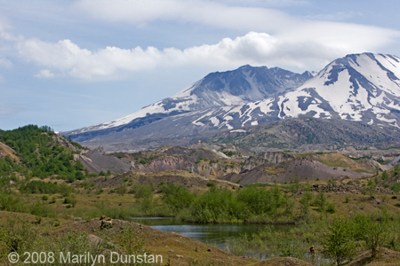
Mt St Helens Steam Eruption, May 20, 2006, viewed from Hummocks Trail showing renewal of vegetation, Mt St Helens National Volcanic Monument (image on Photoshelter)
The road heads downward before the last ascent to the Johnston Ridge Observatory. The Hummocks Trail provides an opportunity to hike amongst the hummocks, created by the Mt St Helens debris avalanche. The debris avalanche created by the eruption of Mt St Helens offered geologists an opportunity to learn about and identify such formations elsewhere.
From the Hummocks Trail, the road then climbs upwards towards Johnston Ridge Observatory at 4,255 feet. As you hike up an incline from the parking lot towards the Visitor Center, you are greeted with a marvelous view of Mt St Helens, looking right down into the throat of the volcano. It is up close and personal, looming as a reminder of the blast impact, as the crater opens up its giant maw to the visitor, you are struck by the awesome power that so forcefully reconstructed the landscape in the wake of its eruption.
As the clouds dance across the crater and the lava dome inside it, you are reminded that Mt St Helens, the youngest of Cascade volcanoes, has not been quiet since it’s May 18, 1980 eruption. Eruptive activity continued into 1986 and then resumed during 2004-2006, including dome building activity.
A visit to the Visitor Center gives the opportunity to explore exhibits, view a movie, “Message from the Mountain”, and attend ranger-guided talks. In one talk, the ranger used still photographs to illustrate various stages of Mt St Helens’s activity leading up to and including the eruption events. We saw Mt St Helens’s pre-eruptive recreational splendor as a near-perfect volcanic cone and glimpses of pre-eruptive awakenings.
As explained by the ranger, volcanic activity beneath the surface of the volcano eroded and weakened the rock structure on the side of the mountain, turning it to clay. This weakened area provided an opportunistic path for the upwelling magma to take, versus the hardened rock plug at the top of the volcano. The side of the mountain bulged with pressure and structural weakening. The landslide and accompanying 5.1 earthquake triggered the event that would unleash the power and fury of Mt St Helens, with resultant lateral blast, pyroclastic flows, lahars (mud flows) and an ejection of ash that would circle the globe.
It is sobering to realize that volcanism can eat away at a mountain’s rock structure from within, weakening it and exposing the mountain to risk of collapse. It is yet another example of a “tipping point” where a marginal change can have a result out of proportion to its own magnitude.
Geologists and volcanologists study volcanoes and other geological system and we are all continually learning from their experience. Johnston Ridge Observatory was named in memory of geologist David Johnston, volcanologist, who witnessed the May 18, 1980 eruption from what is now Johnston Ridge, and radioed in the message “Vancouver, Vancouver, this is it” before perishing in the blast.
The Mt St Helens 1980 eruption has resulted in a continued expansion in knowledge and monitoring tools for understanding the behavior of volcanoes.
In one study, the impacts of volcanic hydrothermal systems on Cascade volcanoes is being studied by the United States Geological Survey.
A wide range of information about Cascade Volcanoes can be found on the Cascade Volcano Observatory (CVO) site.
No comments:
Post a Comment